
東京大学秩父演習林_サワラ人工林成長試験地0401区調査野帳
東京大学大学院農学生命科学研究科附属演習林
UTFEEP(Database for the University of Tokyo Forests Experimental and Ecological forest Plots) | Graduate School of Agricultural and Life Sciences / Faculty of Agriculture

東京大学秩父演習林_スギ人工林成長試験地040SW区調査野帳
東京大学大学院農学生命科学研究科附属演習林
UTFEEP(Database for the University of Tokyo Forests Experimental and Ecological forest Plots) | Graduate School of Agricultural and Life Sciences / Faculty of Agriculture

東京大学秩父演習林_スギ人工林成長試験地0400区調査野帳
東京大学大学院農学生命科学研究科附属演習林
UTFEEP(Database for the University of Tokyo Forests Experimental and Ecological forest Plots) | Graduate School of Agricultural and Life Sciences / Faculty of Agriculture

LANDSAT MAP 1:500,000 (Chubu Mountaineous Region, Central Japan)
Geographical Survey Institute
Digital Map Collection [Center for Spacial Information Science] | Center for Spacial Information Science
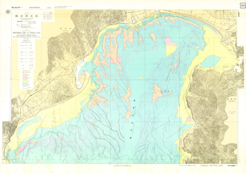
Chart No. 63625-S Northern Part of Suruga Wan
Hydrographic Department, M.S.A.
Digital Map Collection [Center for Spacial Information Science] | Center for Spacial Information Science
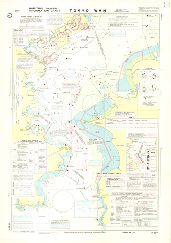
Maritime Traffic Information Charts H-301B Tokyo Wan 1:52,000 (Lat. 35°25')
Japan Hydrographic Association
Digital Map Collection [Center for Spacial Information Science] | Center for Spacial Information Science
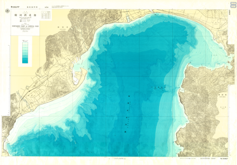
Chart No. 63625 Northern Part of Suruga Wan
Hydrographic Department, M.S.A.
Digital Map Collection [Center for Spacial Information Science] | Center for Spacial Information Science