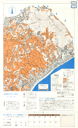
Kanagawa-ken OL Permanent Course 15 MIRURA HANTO TAKEYAMA
Type
Map
Creator
Yokohama Orienteering Club and Orienteering Club Tsurumi
Extent
36cm * 22cm
Description
コレクション: 国際地図・地理展(1980年・東京)
Reference number: JPN C-44-6
Explanation of the object (A): Scale 1:20,000, Contour interval 10 meters, Surveyed at July - Aug. 1979, Base map
Map scale: 1:20,000
Map topic: Base map
Country / Region: Japan
Number of maps: 1
-
Faculty / Graduate SchoolCenter for Spacial Information Science
-
Data ProviderKashiwanoha Paper Maps Digital Archive Project, Center for Spatial Information Science, The University of Tokyo
-
Rightshttps://maparchive.csis.u-tokyo.ac.jp/browse/
-
Metadata Rightshttps://maparchive.csis.u-tokyo.ac.jp/browse/
Collection
-

Digital Map Collection [Center for Spacial Information Science]
This page contains maps from around the world that were collected for the International Cartographic and Geographical Exhibition held in conjunction with the International Geographic Congress & International Cartographic Conference in Japan in 1980 (1980 IGC-ICC). These maps are housed in the Kashiwa Library, the University of Tokyo and have been digitized and made publicly available through the Kashiwanoha Paper Maps Digital Archive Project.
share
関連資料
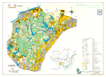
Nishi-Nippon ken Kokusai Orienteering Taikai (West Japan and International Competition) KOHNAN
Japan Orienteering Committee
Digital Map Collection [Center for Spacial Information Science] | Center for Spacial Information Science
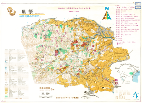
Showa 53 nendo Zen Nippon Orienteering Taikai (All Japan Competition) KAZAMATSURI
Japan Orienteering Committee
Digital Map Collection [Center for Spacial Information Science] | Center for Spacial Information Science
Showa 52 nendo Zen Nippon Orienteering Taikai (All Japan Competition)
Japan Orienteering Committee
Digital Map Collection [Center for Spacial Information Science] | Center for Spacial Information Science
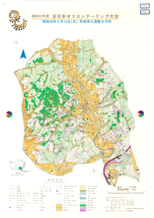
Showa 52 nendo Zen Nippon Orienteering Taikai (All Japan Competition)
Japan Orienteering Committee
Digital Map Collection [Center for Spacial Information Science] | Center for Spacial Information Science
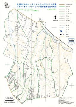
SAPPORO shi Ski Orienteering Competition and Training Course of Ski Orienteering Leaders
Japan Orienteering Committee
Digital Map Collection [Center for Spacial Information Science] | Center for Spacial Information Science
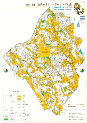
Showa 51 nendo Zen Nippon Orienteering Taikai (All Japan Competition)
Japan Orienteering Committee
Digital Map Collection [Center for Spacial Information Science] | Center for Spacial Information Science