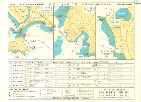
Yachting Charts - Coastal Sailing Series H-176 Tyozya-ga-Saki - E-no-Sima 1:30,000 - Back
Type
Map
Creator
Japan Hydrographic Association
Publisher
Japan Hydrographic Association
Issued
1980
Issued (formated)
1980
Extent
50cm * 35cm
Description
コレクション: 国際地図・地理展(1980年・東京)
Reference number: JPN C-13-2
Explanation of the object (A): Both sides of the charts are waterproofed with special coating, on which pencilling can be made repeatedly. On reverse side, a large scale plan of every Yacht Harbour is shown, and guiding for yachtmen in each marine base is shown in tabular form.
Map scale: 1:30,000
Map topic: Chart
Country / Region: Japan
Name of editor (b): Japan
Name of supervisor (c) : Japan
Name of printer (e): Fuji Seihan-Insatsu K.K.
Name of printer (e): Japan Hydrographic Association
Name of printer (e): JPY 1,000
Number of maps: 1
-
Faculty / Graduate SchoolCenter for Spacial Information Science
-
Data ProviderKashiwanoha Paper Maps Digital Archive Project, Center for Spatial Information Science, The University of Tokyo
-
Rightshttps://maparchive.csis.u-tokyo.ac.jp/browse/
-
Metadata Rightshttps://maparchive.csis.u-tokyo.ac.jp/browse/
Collection
-

Digital Map Collection [Center for Spacial Information Science]
This page contains maps from around the world that were collected for the International Cartographic and Geographical Exhibition held in conjunction with the International Geographic Congress & International Cartographic Conference in Japan in 1980 (1980 IGC-ICC). These maps are housed in the Kashiwa Library, the University of Tokyo and have been digitized and made publicly available through the Kashiwanoha Paper Maps Digital Archive Project.
share
関連資料
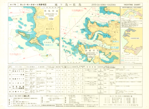
Yachting Charts - Coastal Sailing Series H-175 Zyo-ga-Sima - Sazima 1:30,000 - Back
Japan Hydrographic Association
Digital Map Collection [Center for Spacial Information Science] | Center for Spacial Information Science
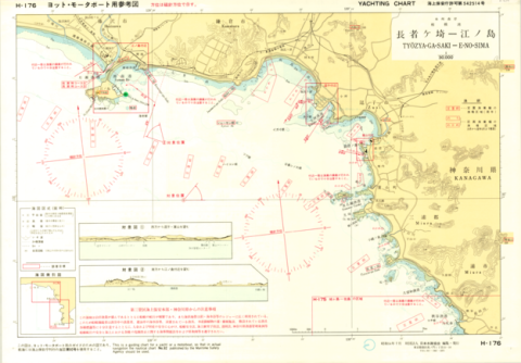
Yachting Charts - Coastal Sailing Series H-176 Tyozya-ga-Saki - E-no-Sima 1:30,000 - Front
Japan Hydrographic Association
Digital Map Collection [Center for Spacial Information Science] | Center for Spacial Information Science
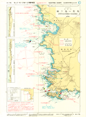
Yachting Charts - Coastal Sailing Series H-175 Zyo-ga-Sima - Sazima 1:30,000 - Front
Japan Hydrographic Association
Digital Map Collection [Center for Spacial Information Science] | Center for Spacial Information Science
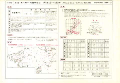
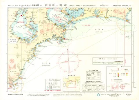
Yachting Charts - Offshore Sailing Series H-112 Omae Saki - Sio-no-Misaki 1:500,000 (Lat. 35°)
Japan Hydrographic Association
Digital Map Collection [Center for Spacial Information Science] | Center for Spacial Information Science
Yachting Charts - Offshore Sailing Series H-112 Omae Saki - Sio-no-Misaki 1:500,000 (Lat. 35°)
Japan Hydrographic Association
Digital Map Collection [Center for Spacial Information Science] | Center for Spacial Information Science
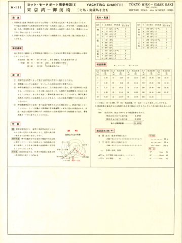
Yachting Charts - Offshore Sailing Series H-111 Tokyo Wan - Omae Saki 1:500,000 (Lat. 35°)
Japan Hydrographic Association
Digital Map Collection [Center for Spacial Information Science] | Center for Spacial Information Science