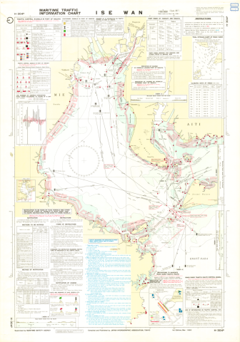
Maritime Traffic Information Charts H-304B Ise Wan 1:100,000 (Lat. 35°)
種別
地図
編著者
Japan Hydrographic Association
出版者
Japan Hydrographic Association
刊行年、書写年等
1980
刊行年月日(西暦)
1980
形態
100cm * 70cm
内容記述
コレクション: 国際地図・地理展(1980年・東京)
Reference number: JPN C-8
Explanation of the object (A): The boundaries of traffic routes and other useful information concerning maritime traffic are shown by symbols and article expressions. Mercator's Projection, 6 colours.
Map scale: 1:100,000
Map topic: Chart
Country / Region: Japan
Name of editor (b): Japan
Name of supervisor (c) : Japan
Name of printer (e): Kokudo Mapping Co., Ltd.
Name of printer (e): Japan Hydrographic Association
Name of printer (e): JPY 1,000
Number of maps: 1
-
部局空間情報科学研究センター
-
提供者東京大学空間情報科学研究センター柏の葉紙地図デジタルアーカイブ化プロジェクト
-
メディア(画像等)利用条件https://maparchive.csis.u-tokyo.ac.jp/browse/
-
メタデータ利用条件https://maparchive.csis.u-tokyo.ac.jp/browse/
コレクション名
-

柏の葉紙地図デジタルアーカイブ
東京大学柏図書館に所蔵されている、国際地図・地理展(1980年・東京)のために収集された世界各国の地図を、柏の葉紙地図デジタルアーカイブ化プロジェクトによりデジタル化した地図を閲覧することができるサイトです。
シェアする
関連資料
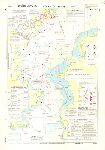
Maritime Traffic Information Charts H-301B Tokyo Wan 1:52,000 (Lat. 35°25')
Japan Hydrographic Association
柏の葉紙地図デジタルアーカイブ | 空間情報科学研究センター
Yachting Charts - Offshore Sailing Series H-112 Omae Saki - Sio-no-Misaki 1:500,000 (Lat. 35°)
Japan Hydrographic Association
柏の葉紙地図デジタルアーカイブ | 空間情報科学研究センター
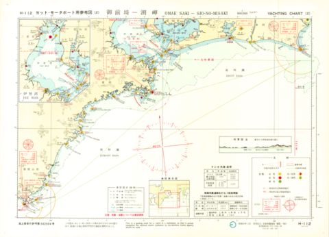
Yachting Charts - Offshore Sailing Series H-112 Omae Saki - Sio-no-Misaki 1:500,000 (Lat. 35°)
Japan Hydrographic Association
柏の葉紙地図デジタルアーカイブ | 空間情報科学研究センター
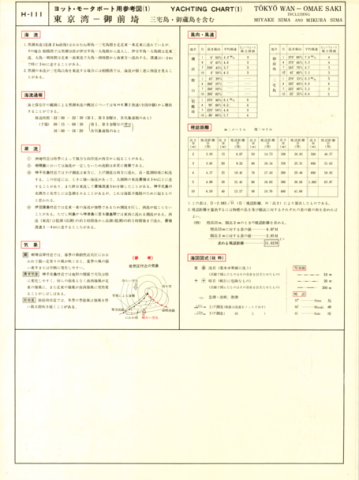
Yachting Charts - Offshore Sailing Series H-111 Tokyo Wan - Omae Saki 1:500,000 (Lat. 35°)
Japan Hydrographic Association
柏の葉紙地図デジタルアーカイブ | 空間情報科学研究センター
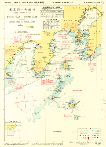
Yachting Charts - Offshore Sailing Series H-111 Tokyo Wan - Omae Saki 1:500,000 (Lat. 35°)
Japan Hydrographic Association
柏の葉紙地図デジタルアーカイブ | 空間情報科学研究センター
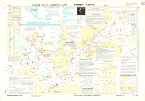
Maritime Traffic Information Charts H-310B Kanmon Kaikyo 1:23,000
Japan Hydrographic Association
柏の葉紙地図デジタルアーカイブ | 空間情報科学研究センター