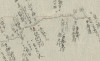
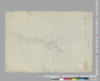
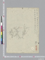
[14]従信州水内郡長野村内善光寺宿善光寺門前飯山湏坂松代ヲ歴テ至高井郡屋代宿旧測印 : 六分一里之図
Language
Japanese
Type
StillImage
Extent
93枚
Description
資料名:測地原圖
その他の資料名:測地原稿図
その他の資料名よみ:そくちげんこうず
その他の資料名:伊能図
その他の資料名よみ:いのうず
その他の資料名:従 信州水内郡長野村内善光寺宿善光寺門前飯山須坂松代ヲ歴テ 至 高井郡屋代宿
請求記号:A00:4549
刊写の別:写
-
Faculty / Graduate SchoolGeneral Library
-
Original OwnerGeneral Library, The University of Tokyo
-
Data ProviderGeneral Library, The University of Tokyo
-
Rightshttps://www.lib.u-tokyo.ac.jp/ja/library/contents/archives-top/reuse
-
Metadata Rightshttp://creativecommons.org/licenses/by/4.0/

-
IIIF manifesthttps://da.dl.itc.u-tokyo.ac.jp/portal/repo/iiif/68cf6f00-3081-069c-0fb2-306b821f9815/manifest
Collection
-
Sokuchi genzu
The geodetic maps "Sokuchi-Genzu" are a group of maps that describe the results of surveys carried out by Ino Tadataka (1745-1818) in the early 19th century, also known as ‘Ino maps’.
share
関連資料
[5]自信州筑摩郡洗馬宿大門村歴松本至更級郡川中嶋塩崎江戸善光寺道追分并姨捨山 : 六分一里之圖
Sokuchi genzu | General Library
[6]従飛刕大野郡無數河村ム印高山町ヲ歴至信刕筑摩郡藪原宿制札 : 六分一里之図
Sokuchi genzu | General Library
[7]従信州佐久郡借宿村下仁田通り至武州兒玉郡本庄宿制札多胡碑 : 六分一里之図
Sokuchi genzu | General Library
[37]自美濃不破郡赤坂宿谷汲山ヲ歴テ至山縣郡岐阜町及厚見郡東鏡嶋鏡嶋村境 : 六分一里之図
Sokuchi genzu | General Library
[3]従武州大里郡熊谷宿歴川越至入間郡大仙波新田大印 : 六分一里之圖
Sokuchi genzu | General Library
[18]従作州大庭郡下長田村字犬挟峠長印至伯州日野郡二部村字間地, 備中阿賀郡小坂部村未年壬二月残印, 同上房郡片岡村字塩坪前同年残印, 作州大庭郡久世村原方中嶋村境中印 : 六分一里之圖
Sokuchi genzu | General Library