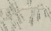
[4]自江府深川測処至大堀村 : 㐧一圖之内猫実 : 六分一里の圖
Language
Japanese
Type
StillImage
Extent
93枚
Description
資料名:測地原圖
その他の資料名:測地原稿図
その他の資料名よみ:そくちげんこうず
その他の資料名:伊能図
その他の資料名よみ:いのうず
その他の資料名:自 江府深川測処 至 大堀村
請求記号:A00:4549
刊写の別:写
-
Faculty / Graduate SchoolGeneral Library
-
Original OwnerGeneral Library, The University of Tokyo
-
Data ProviderGeneral Library, The University of Tokyo
-
Rightshttps://www.lib.u-tokyo.ac.jp/ja/library/general/reuse

-
Metadata Rightshttps://creativecommons.org/publicdomain/zero/1.0/

-
IIIF manifesthttps://da.dl.itc.u-tokyo.ac.jp/portal/repo/iiif/d1ba2b6b-19cd-9336-9d31-eca0f7f1a602/manifest
Collection
-
Sokuchi genzu
The geodetic maps "Sokuchi-Genzu" are a group of maps that describe the results of surveys carried out by Ino Tadataka (1745-1818) in the early 19th century, also known as ‘Ino maps’.
share
関連資料
[19]西国街道五 : 自備後安那郡川北村神辺至安藝豊田郡夲郷村測処又福山測所 : 六分啚
Sokuchi genzu | General Library
[5]自信州筑摩郡洗馬宿大門村歴松本至更級郡川中嶋塩崎江戸善光寺道追分并姨捨山 : 六分一里之圖
Sokuchi genzu | General Library

[28]自大隅國桑原郡濵市村野尻ヲ歴テ加久藤本庄ニ至ル : 六分一里之図
Sokuchi genzu | General Library
[22]西国街道一 : [従]山城淀測処[至]播磨神戸村 : 六分一里之図
Sokuchi genzu | General Library
[12][自葛西川村歴亀戸村小名木村至入舩町] : 三寸六分一里
Sokuchi genzu | General Library
[24]第三十七番 : 自田老村至唐丹之圖
Sokuchi genzu | General Library