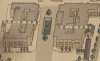
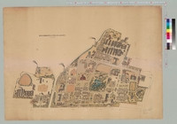
東京帝國大學農學部建物位置圖
トウキョウ テイコク ダイガク ノウガクブ タテモノ イチ ズ
Tokyo teikoku daigaku nougakubu tatemono ichi zu
Alternative title
東京帝國大學農學部建物位置圖 : 大正十一年四月一日現在
東京帝国大学農学部建物位置図 : 大正11年4月1日現在
Language
Japanese
Type
Map
Creator
[東京帝國大學農學部]
Issued
[大正11(1922)]
Created (formated)
1922
Extent
地図1枚 + 付図1枚
Description
請求記号:和:26
縮尺: 1:600書名上部に"東京府荏原郡目黒村、世田谷村豊多摩郡代々幡町、澁谷町"とあり
資料の解説: 大正11(1922)年の駒場キャンパスの構内図です。当時、農学部は駒場にありました。この図では建物に番号が振られ、番号と建物名称の表が付いています。圃場を含む敷地全体が描かれており、現在の駒場キャンパスよりも広い敷地だったことがわかります。 参照:現在の駒場地区キャンパスマップ https://www.u-tokyo.ac.jp/ja/about/campus-guide/map02_01.html
-
Faculty / Graduate SchoolGraduate School of Agricultural and Life Sciences / Faculty of Agriculture
-
Original OwnerUniversity Library for Agricultural and Life Sciences, The University of Tokyo
-
Data ProviderUniversity Library for Agricultural and Life Sciences, The University of Tokyo
-
Rightshttps://www.lib.u-tokyo.ac.jp/ja/library/contents/archives-top/reuse
-
Metadata Rightshttp://creativecommons.org/licenses/by/4.0/

-
IIIF manifesthttps://da.dl.itc.u-tokyo.ac.jp/portal/repo/iiif/6d032fb5-0a2f-6e04-9e3c-6bb5f604714f/manifest
Collection
-
Agri. Library, UTokyo Collection
Rare books held in University Library for Agricultural and Life Sciences, the University of Tokyo have been digitized and made available on this page.
share
関連資料
東京帝國大學本部構内及農學部建物鳥瞰圖
[東京帝國大學]
Agri. Library, UTokyo Collection | Graduate School of Agricultural and Life Sciences / Faculty of Agriculture
群芳圖譜 第1輯第9編
和田英作,佐藤醇吉著
Agri. Library, UTokyo Collection | Graduate School of Agricultural and Life Sciences / Faculty of Agriculture
群芳圖譜 第1輯第2編
和田英作,佐藤醇吉著
Agri. Library, UTokyo Collection | Graduate School of Agricultural and Life Sciences / Faculty of Agriculture

群芳圖譜 第1輯第1編
和田英作,佐藤醇吉著
Agri. Library, UTokyo Collection | Graduate School of Agricultural and Life Sciences / Faculty of Agriculture
群芳圖譜 第1輯第3編
和田英作,佐藤醇吉著
Agri. Library, UTokyo Collection | Graduate School of Agricultural and Life Sciences / Faculty of Agriculture

群芳圖譜 第1輯第4編
和田英作,佐藤醇吉著
Agri. Library, UTokyo Collection | Graduate School of Agricultural and Life Sciences / Faculty of Agriculture